Editor’s Note
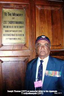
Fifty years after the 1962 war with China, a great deal is being said and written about the event. Tomorrow happens to be the 50th anniversary of the martyrdom of our course mate, 2/Lt T Achyutharayalu, of the Sikh LI, who made the supreme sacrifice at Sela. He was a classmate of Joseph Thomas in School. To mark this occasion, Thomas has written a brief piece on the subject, which is worthy of consideration.
Thomas was a brilliant student who topped the entrance order of merit of the XIX NDA course, and retained his position all through the six terms. He passed out First in the order of merit, and won the Silver Medal. That apart, he has the following credentials to speak on this subject with conviction and authority.
-
He was still in his teens when he joined 43 Squadron, flying in J & K. Became 20 during the 1962 war. Flew Dakotas in the transport support role. He did aerial survey from 1967 onwards flying Canberras. In 1980 – 81 he commanded the same squadron. In 1972, he was awarded the Vayu Sena Medal for the excellent job done in this field.
- Later, he was posted in the Cabinet Secretariat (Military Wing) where he got an opportunity to study the subject in great detail, and he was also privy to several high level meetings on this issue.
- He wrote some papers on this subject which did make a difference, though not immediately, but in due course of time.
- His views may be considered as radical by some readers, but I think they are definitely worthy of serious thought and discussion.
- A graduate from the Defense Services Staff College, he has also been an instructor there. Since he attended the Lawrence School, Lovedale, before joining the NDA, he has spent more years in the Nilgiri Hills, than any one else whom I know.
*
INDIA CHINA BORDER – THE WAY FORWARD
By Veteran Wing Commander Joseph Thomas, VM
Three decades ago, when my team was tasked with aerial survey of the Macmahon Line (ML), I was asked whether I knew the Chinese version of the ML. Even though a veteran of the 1962 war, I had never before heard of a Chinese version. Surprised, I went into the matter a little more deeply and made some startling discoveries. Not the least among them is that both sides have been talking at each other, rather than to each other.
The moot point is “Where is the ML?”
Macmahon was the Foreign Secretary of India. A former army engineer, he was a specialist in survey and had worked on demarcating the Durand Line. He convened the 1913 – 1914 Shimla conference to delineate a Tibet-China border. During the conference, Mac and Lonchen Shatra Dorje, the Tibetan representative, negotiated an agreement to delineate a boundary between Tibet and India in the Eastern sector. It did not cover the middle and western sectors. Mac put his seal and Lonchen Shatra signed (because Tibetans do not initial). It was, therefore, subject to ratification by the respective governments. The Chinese representative, Ivan Chen, initialed one of the maps but not all. On 03 Jul 1914 he declared serious differences over the proposed China – Tibet border and went home. Subsequently, both Tibet and India did not ratify the agreement. An agreement that is initialed but not ratified has no validity. This is very elementary.
We claim that the intent of the treaty was to follow the highest ridges of the Himalayas. We claim that south of the high ridges should be Indian territory and North of the high ridges should be Chinese territory. Starting from the 1950s, when India began patrolling this area, we found that at multiple locations, the highest ridges fell north of the McMahon Line as shown in the treaty map. We modified our maps to extend the ML northwards to include features such as Thag La, Longju, and Khinzemane as Indian Territory. The actual treaty map itself is topographically vague and the treaty includes neither verbal description of geographic features nor description of the highest ridges. Defining the boundary is a bilateral issue and it was a mistake to do it unilaterally.
The Central sector has only minor issues and is not a bone of contention.
The Northern sector (Ladakh) is more tricky. A boundary between Ladakh and Ari (Western Tibet) was verbally defined circa 930 AD and was re-affirmed in 1684 and 1842. The Chinese and we have different interpretations of this border at Demchok, Chushul, and Khurnak Fort etc. But these differences are minor and can be reconciled, given the political will. The problem lies in Aksai Chin which was not part of the 930, 1684 or 1842 agreements.
Till 1960 our maps showed the eastern boundary of Aksai Chin as “Undefined.” A dotted line was printed to depict our claim line. When the dispute with China hotted up, we printed new maps depicting the Aksai Chin boundary as a regular international boundary. Yet another instance of unilateral action where bilateral negotiations were called for.
In 1960 Chou En Lai visited New Delhi and offered to accept the Mac Line in exchange for our accepting Aksai Chin as theirs. It was a fair offer, considering that our early maps showed the whole of Arunachal as being outside India. Indeed, our administration moved into Tawang only in 1951. Not that it was Chinese at that time. It was neither in India nor in Tibet. But Chou En Lai was rebuffed.
Viewed from the Chinese side, Indians claimed the Mac Line as the border but repeatedly occupied land beyond it. Also, from their point of view, Aksai Chin was “No Man’s Land” and they were the first to occupy it.
In 1962 things hotted up. In July there was the Galwan incident. The Thag La action started on 08 Sept. In October there was a 2nd Galwan incident. Now, Thag La lies on the Tibetan side of the Mac Line. We unilaterally altered the Mac Line to include it on our side. 7 Infantry Brigade was ordered to hold this disputed territory.
After the defeat of 7 Inf Bde, the Chinese govt paused and Chou sent another letter to Nehru. This letter from Chou in early November was conciliatory but shows how the Chinese could never understand the rationale behind our actions. The letter starts with the usual greetings and goes on to say “Mr. Prime Minister, India is a great country with an ancient civilization. China is also a great country with an ancient civilization … Then he says “Your claim is the Mac Line. Your govt will, no doubt, have an original copy of the Mac Line. Please look at the original map and you will see that the Mac Line moves eastward from the trijunction with Bhutan at (xxx lat and long) to (xxx lat and long) to (xxx lat and long). Why then are your troops beyond this line? Why do you claim territory beyond the line?” (Or words to that effect.) Chou proposed a cease fire and a pullback to 20 km on either side of the 08 Sep 62 positions. We rejected this offer too and fighting resumed with disastrous results for us.
The unilateral cease fire and pull back by China has to be seen in the context of the time. We altered the Mac Line unilaterally and then declared it our sacred territory. Similarly, there was no defined boundary in the Aksai Chin area. Our own official maps said so. We were instructed to replace the dotted line with a thick black line and make it the international border. Again an unilateral action when bilateral negotiations were called for. For the life of me, I have not able to find out who initiated the idea of unilaterally fixing our boundaries.
Let us be glad that the Chinese withdrew. They could have ceased fire and held on to whatever they had gained.
From War to Dialogue
In 1988 Prime Minister Rajiv Gandhi visited China, the first PM to visit China in 34 years. Both countries agreed to set up a joint working group to settle the boundary issue. In 1991 Chinese Premier Li Peng visited India and pledged to resolve the boundary question through friendly consultations.
1993 was a landmark year when Prime Minister P.V. Narasimha Rao visited China and signed an agreement on Border Peace and Tranquility. This essentially signaled an intent to freeze the Line of Actual Control (LAC) as the international border.
Since 1993 India and China have moved forward on various fronts. Trade has expanded to the point where China has become one of our largest trade partners and vice versa. However, the border issue remains an irritant. It is time to settle our borders on the basis of the 1993 agreement and then to demarcate it on the ground. As this article has shown, it would be recognition of ground realities and will be fair to both sides.
It is high time we move on.
Some pictures that tell the tale, better than words

This is taken from a Dakota of 43 squadron. One wing of the Dakota is seen. The picture is of crossing the Nila La pass en route to Thoise, the Sasser Range and the Chip Chap valley.

As squadron commander of the photo squadron in 1981
And here is a picture of great historic value.

The picture shows the participants in the Simla Conference 1913-14

This is the McMahon Line Map 1 from the Bhutan tri-junction to the Tsang Po/Dihang/Brahmaputra. This is a very important map, because it covers the Thag La area where the fighting started

This is the Mcmahon Line, Map 2 covering the “fishtails.” It extends upto the tri-junction of Burma, Tibet and China. Prior to 1937, Burma was a province of British India. It is noteworthy that, when China and Burma settled their border in 1960, they defined it along the McMahon Line.
These pictures show the vintage of the maps and the lack of clarity — no contours. We surveyed this line by first flying at maximum altitude, taking pictures and making a mosaic. The pictures and mosaic were in black & white and so it was really difficult.
CITATION FOR THE AWARD OF VM TO SQUADRON LEADER J THOMAS IN JAN 1972
Squadron Leader Joseph Thomas has been a pilot in the Indian Air Force for ten years.
This officer served in a reconnaissance squadron for four years. In this time he flew 230 sorties of aerial survey, which required very accurate planning and execution. Flying over rugged, mountainous terrain using inaccurate maps he achieved results of a very high standard. On two occasions when his aircraft was crippled by mechanical failures he brought back the disabled aircraft safely to base. For his professional acumen, presence of mind and unflinching devotion to duty, Squadron Leader Thomas is awarded the Vayu Sena Medal.
Tailpiece.
And I end this piece with two pictures of Thomas and his wife, Elsie. The first was taken in the USA about three years after their wedding and the second is a relatively recent photograph, no more than ten years old. They now look much ‘wiser’!


ADDENDUM — 24 JUNE 2020
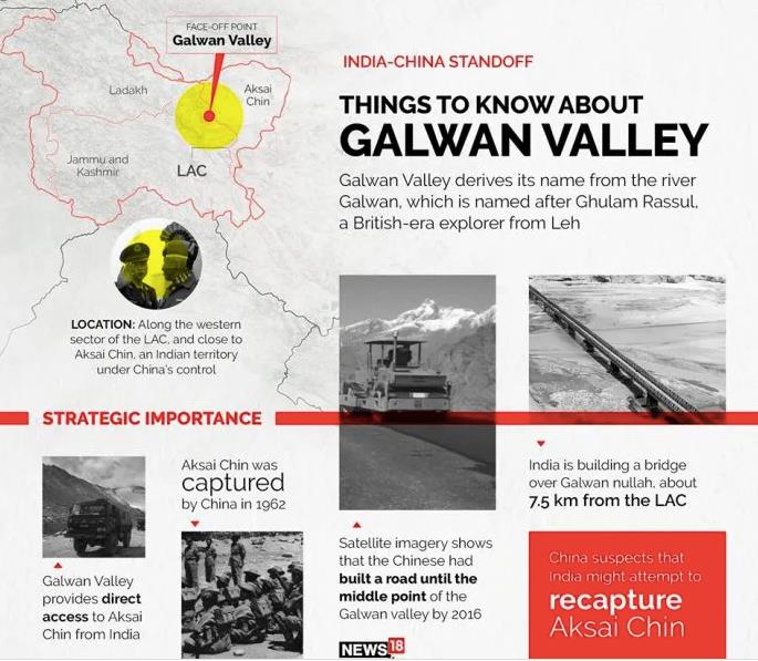
The recent clash at Galwan has changed the whole picture. It is a watershed event.
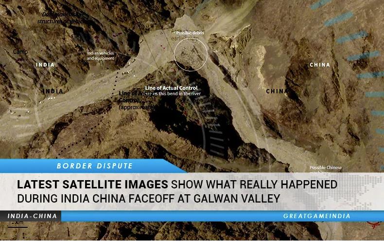
All our efforts at maintaining Peace and Tranquillity on the border, as agreed between the two countries, have gone down the Galwan river. The Chinese may be wanting to patch up but, at the same time, they are claiming the entire Galwan river basin. This is preposterous. While the source of the Galwan river is in Aksai Chin, the scene of the recent clash is outside Aksai Chin.
All the people in the know have reported that the Chinese decline to accept our map of the LAC and also decline to present a map of their version of the LAC. How then is it possible to agree on delineation of the boundary, much less demarcation ? The only possible conclusion is that we have bent over backwards, compromised and let the Chinese get away with some gains each time they resort to a creeping advance.
My podcast on “Mapping the India China Border” under the auspices of the Bangalore International Centre is at
https://bangaloreinternationalcentre.org/audio/mapping-the-india-china-border-with-joseph-thomas/
It is also available on YouTube too
Enough is enough. Diplomacy has failed. The time has come for military action. 16 Bihar and others at Galwan have shown the way.
“China is not the first power to be overwhelmed by narcissism and hubris. Imperial Japan and Nazi Germany believed they were unstoppable in Asia and Europe in the run-up to the Second World War.”
Editorial : https://indianexpress.com/article/opinion/editorials/india-china-border-dispute-ccp-6467167/
As Capt Amarinder Singh ( XXIII Course – NDA) has said “China has a bigger Army, not a better Army.” The same applies to the air forces and the navies.


[...] busy earning a living and pursuing the India China border issue. (See China – India Border http://amolak.in/web/sino-indian-border-the-way-forward-by-j-thomas/ [...]
[...] Read more at http://amolak.in/web/sino-indian-border-the-way-forward-by-j-thomas/ – See more at: http://amolak.in/web/sino-indian-border-the-way-forward-by-j-thomas/#sthash.sgvfOO2j.dpuf [...]
It is always a learning experience to read anything written by JT. Whether it is history, politico-military affairs, earth science matters or plain reviews, one can feel the depth of attention to detail and the painstaking research work put in. The final product is something that is eminently readable and educative. His writings are also noteworthy because of his fearless stance on controversial issues, his manifest ability for out of the box thinking and the unusual solutions he manages to come up with. His command over the English language is commendable. His style is direct, uncomplicated and down-to-earth.
There is an ill informed, self contradictory article in the Sunday Guardian of 30 Aug 14. See
http://www.sunday-guardian.com/news/manmohan-did-not-correct-map-error-to-protect-nehru-name
Manmohan did not correct map error to protect Nehru name
Herewith the comment I have posted there :
Mr Madhav Nalapat has written a self contradictory article. Obviously he does not know the subject and appears to have relied on a briefing given by an equally innocent civil servant.
Firstly, the “fishtails” are shown as Tibetan territory in the MacMahon Line. That line is known internationally. The author does acknowledge that “China has settled its boundary with Myanmar on the basis of the McMahon Line” [even though China has never accepted the Macmahon Line].
The author is right when he says “the area within the two fishtails has always been occupied by our troops, as well as by the Mishmi tribe, all of whom are citizens of India.”
True, but our official, published maps (and the Macmahon Line] show the fishtails to be in Tibet, which we have recognised as part of China.
Nehru’s mistake was to engage in gunboat diplomacy with China. He essentially declared war on China on 11 October 1962 when he said that the Army had been instructed to “throw out the Chinese.” Mr Nalapat and his handlers are engaging in the same gunboat diplomacy with China. Come on, gentlemen, China is a neighbour and a major power. She deserves at least as much respect as we give to our other neighbours.
Mr Nalapat has, in the middle of the article, suddenly jumped to the Depsang Plains, which are part of Aksai Chin in the Northern sector. Pray what is the connection with the fishtails in Arunachal Pradesh ?
And sir, the Cocos Islands are part of Myanmar. Nobody has gifted them to China. As the sovereign of the islands, Myanmar has permitted China to establish some facilities there. No Indian government has had any role in the matter. It is absurd to blame Nehru for this.
The article is so riddled with inconsistencies and errors of fact that a complete rebuttal is not necessary.
There is an interesting article in The Statesman today. Please see
http://thestatesman.net/app/storyios.html?uniid=6&storyitem=0
I have posted a comment :
“The author is quite right. In 1993 we signed an Agreement to Maintain
Peace and Tranquillity on the LAC. The idea was essentially to freeze the
LAC as the international border. It is high time we move forward and
jointly demarcate the border on the ground.”
Recent incidents in Apr/May 2013 in Ladhak sector,consequent visit of new Chinese President to India,out cry in Indian media,all this requires mature understanding of realities and not allowing Peace and tranquility to be disturbed at the border on both sides.One hopes positive steps are taken when our PM visits China shortly.Meanwhile articles on factual position must appear in Indian Newspapers/magzines to avoid emotional reactions by Public/media
As I was going through this paper and the comments, I was reminded of an ultra-short story which I read many years ago. Here is how it goes:
“A rich man’s son wanted to build an orchard. When he had acquired all the necessary academic knowledge and qualifications, the family purchased a piece of land and started the process of planting trees. The first problem came from a neighboring farmer, in a social get together. The issue seemed unrelated with the farm, but it led to a clash. Soon enough, the problems became serious. There was a dispute over the right to passage to a certain field, and then other issues concerning irrigation and the effect of the fruit trees on soil preservation came in. The nasty neighbor went on to assert that when the trees attained the full height, their shadow would adversely affect his crops. The villain in this story was able to muster enough local support to uproot some of the saplings planted by our friend, well within his duly fenced plot of land.
The young man was livid, and turned to his father for help. The head of the family did his bit of analysis, and after due thought, he went over to a renowned lawyer. After a deliberate examination of documents and the laws on the subject, the attorney went to his client, and said :
“Sir, I have rarely handled a case stronger than this. When do we file the suit?”
The shrewd elder looked deep into the eyes of the lawyer and said,
“Never. I gave you the opponent’s side of the story!”
In a manner of speaking, this also explains how he acquired his wealth! “
Dear Tommy,
Greetings.
I happened to read your very original and informative write up on Sino-Indian border.
I congratulate you on such a well researched and detailed analysis. But then I never expect any thing less from my good friend. Keep writing…God Bless.
Jayarao
Educating public and Parliamentarians of facts, on both sides should begin with out further delay.
An absolutely brilliant and constructive article (also responses to comments) by Veteran Thomas. He displays exceptional clarity of understanding and vision as also courage in articulating his views-my salute, Sir.
All well-meaning Indians ought to support such principled and pragmatic thinking. Blame games and the psyche of finger-pointing are not only odious but the domain of the small-minded. There are overwhelming challenges ahead for us Indians and the proposed way out of the Northern Border seems eminently sensible.
Thank you, sir
Reply by J Thomas to Improveacrati post of November 24, 2012 at 5:25 AM
The aim is to solve this longstanding border problem, not to point fingers.
The events of 1962 were like a Greek tragedy – all the actors were good people and had good intentions. Nevertheless, the end was tragic.
Freezing the LAC as the international border was the intent of the 1993 agreement to maintain Peace & Tranquillity on the border. It would “exchange” our claim on Aksai Chin for the areas we hold beyond the McMahon Line. Therefore, it is fair and reasonable to both sides.
It is essential to proceed on a “no fault, no blame” basis
Excellent article.
Could not agree more with your conclusion that we must move on.
best wishes
Indranil
Dear Joseph,
Thanks for the erudite and well researched reply. It is coincidental that the India-China map drawing row seems to have further escalated (Reuters: India is stamping its own map on visas it issues to holders of new Chinese passports that contain a map depicting disputed territory within China’s borders, the latest twist in tension in Asia over China’s territorial claims. China’s new microchip-equipped passports contain a map that marks its claims over disputed waters and also show as its territory two Himalayan regions that India also claims) while we exchanged e-mails.
I apologize for the sequence in which I recited history. Also, you are right that Tibet had never laid claim on Askai Chin, as historically, it had been a bone of contention between Kashmir and Sinkiang. Askai Chin (perhaps its fringes) were traversed as the “southern arm of the silk route” by Indians and Tibetans to access Kashghar and Khotan (the Indian position, as stated by Nehru (a Kashmiri), was that the Aksai Chin was “part of the Ladakh region of India for centuries” and that this northern border was a “firm and definite one which was not open to discussion with anybody”). If we go further into the past, Buddhism spread from India to the Taklamakan probably via Askai Chin. It is more accurate to describe Askai Chin as a travellers’ land rather than “no-man’s land”. However, in view its potential mineral value, it couldn’t (sadly) have been left that way.
But back to British India’s wavering map drawing with the following excerpt from Wikipedia. W. H. Johnson proposed the “Johnson Line” in 1865, which put Aksai Chin in Kashmir. This was the time of the Dungan revolt, when China did not control Xinjiang, so this line was never presented to the Chinese.Johnson presented this line to the Maharaja of Kashmir, who then claimed the 18,000 square kilometres contained within, and by some accounts territory further north as far as the Sanju Pass in the Kun Lun Mountains. Johnson’s work was severely criticized for gross inaccuracies, with description of his boundary as “patently absurd” Johnson was reprimanded by the British Government. According to Younghusband, who explored the region in the late 1880s, there was an abandoned fort at Shahidulla apparently been built a few years earlier by the Kashmiris. In 1878 the Chinese had reconquered Xinjiang, and by 1890 they had Shahidulla. By 1892, China had erected boundary markers at Karakoram Pass. In 1897, Sir John Ardagh, proposed a boundary line along the crest of the Kun Lun Mountains north of the Yarkand River. At the time Britain was concerned at the danger of Russian expansion as China weakened, and Ardagh argued that his line was more defensible. The Ardagh line was effectively a modification of the Johnson line, and became known as the “Johnson-Ardagh Line”. In 1911, the Xinhai Revolution resulted in the collapse of central power in China, and by the end of World War I, the British officially used the Johnson Line. However they took no steps to establish outposts or assert actual control on the ground. In 1927, the line was adjusted again as the government of British India abandoned the Johnson line in favor of a line along the Karakoram range further south. However, the maps were not updated and still showed the Johnson Line.
When British officials learned of Soviet officials surveying the Aksai Chin for the warlord of Sinkiang in 1940-1941, they again advocated the Johnson Line. At this point the British had still made no attempts to establish outposts or control over the Aksai Chin, nor was the issue ever discussed with the governments of China or Tibet, and the boundary remained undemarcated at India’s independence.
You are right in your article that India and China should urgently settle this issue keeping ground realities in mind. Both China and India should abandon their approach of entering negotiations with maximalist positions.
Regards.
Sriram
P.S. I have not read the history of India’s claim on Arunachal Pradesh.
@sriram,
Thanks. If we settle the border problem, I suppose the Chinese will allow Indian visitors to Aksai Chin. It’s a bleak, desolate, windswept cold desert. Uninhabited save for the Chinese military.
You can see photos of Aksai Chin at https://www.google.co.in/search?q=aksai+chin+photos&ie=utf-8&oe=utf-8&aq=t&rls=org.mozilla:en-US:official&client=firefox-a
However, I think that the lake (DSCF1361-vi) is not a pic taken in Aksai Chin.
Ref “It is coincidental that the India-China map drawing row seems to have further escalated (Reuters: India is stamping its own map on visas it issues to holders of new Chinese passports that contain a map depicting disputed territory within China’s borders, the latest twist in tension in Asia over China’s territorial claims. China’s new microchip-equipped passports contain a map that marks its claims over disputed waters and also show as its territory two Himalayan regions that India also claims)”
Yes, this is an unfortunate development. We need to settle the border issue, taking the 1993 agreement to its logical conclusion
Ref : “If we go further into the past, Buddhism spread from India to the Taklamakan probably via Askai Chin. It is more accurate to describe Askai Chin as a travellers’ land rather than “no-man’s land”. However, in view its potential mineral value, it couldn’t (sadly) have been left that way. ”
Aksai Chin has never been a traveller’s land. The trade route from Leh to Yarkand, Khotan and Kashgar went up the Shyok river valley, then up the Chip Chap river valley and then via the Karakorum Pass. Daulat Beg Oldi was the caravan stop where the climb from the Chip Chap valley started. This route is still with India and does not go through Aksai Chin. BTW the Karakorum Pass is in the Kun Lun range. You can see this on Google maps.
A travel route preferably has water supply en route. Even desert routes are from oasis to oasis. Aksai Chin rarely has water.
Minerals in Aksai Chin — possible, maybe probable.
Ref : “But back to British India’s wavering map drawing with the following excerpt from Wikipedia.
————-some snipped ———— However, the maps were not updated and still showed the Johnson Line.
“When British officials learned of Soviet officials surveying the Aksai Chin for the warlord of Sinkiang in 1940-1941, they again advocated the Johnson Line. At this point the British had still made no attempts to establish outposts or control over the Aksai Chin, nor was the issue ever discussed with the governments of China or Tibet, and the boundary remained undemarcated at India’s independence.”
Yes, it’s a can of worms. The bottom line is that the boundary remained undefined. Demarcation can take place only after the two sides define the boundary. Defining on a map is called “delineation” and that is what Mcmahon attempted in the eastern sector. Demarcation can only happen after delineation. Demarcation is a bilateral process whereby survey officials of both sides jointly survey the boundary, put down boundary pillars, mark them on master maps and authenticate the whole process. We have done it with all neigbouring countries, except China.
Incidentally, some part of the demarcation process can be done by air.
[...] ~ 10 Comments ~ [...]
http://improveacrati.wordpress.com/2012/10/07/the-1967-india-china-armed-clash/
The Chinese learnt their lesson in 1967. Since then there have been no major clashes.
The aim is to solve this longstanding border problem, not to point fingers.
The events of 1962 were like a Greek tragedy – all the actors were good people and had good intentions. Nevertheless, the end was tragic.
Freezing the LAC as the international border was the intent of the 1993 agreement to maintain Peace & Tranquillity on the border. It would “exchange” our claim on Aksai Chin for the areas we hold beyond the McMahon Line. Therefore, it is fair and reasonable to both sides.
It is essential to proceed on a “no fault, no blame” basis.
Dear Surjit
Will be grateful if you could mail me contact details of Wg Cdr Thomas. I liked his very informative article on the Indo-China bdy.
With best wishes & regards for undertaking so useful a commitment of keeping us veterans in the info loop.
Sincerely, Sushil
Dear Surjit,
Thnx,Surjit,
Slicerely,
Ravi
Dear General,
I looked at this piece (http://amolak.in/web/sino-indian-border-the-way-forward-by-j-thomas/) with great interest – first because Wing Cdr. Thomas is a fellow Lawrencian (incidentally I visited Lawrence just a week ago) and the interest I have in the subject.
I think that Wng. Cdr. Thomas may have overlooked a few aspects of history. The MacMohan agreement (perhaps not formalised) was between the British-India Government and the Tibetans. Suspicion between the two ran high particularly in the context of the Great Game. Following the subsequent annexation of Tibet by China and the diplomatic quid pro quo (the sanity of this is questionable) of India offering to both host a Tibetan government in exile as well as recognise Chinese suzerainty over Tibet, one might think that India would have expected something in return.
One question is: where do the Tibetans (or the Dalai Lama) stand on Askai Chin or Arunachal Pradesh?
Regards.
Sriram
Ref : “I think that Wng. Cdr. Thomas may have overlooked a few aspects of history.
The MacMohan agreement (perhaps not formalised) was between the
British-India Government and the Tibetans. Suspicion between the two ran
high particularly in the context of the Great Game.”
The first and most important point is that British rule in India was always
a joint venture. The number of Brits in India, including the police and the
army, never exceeded 50,000. By way of perspective, today a far larger
number of Indian origin people reside in London alone.
The Great Game was an intense rivalry between the British and Russian
Empires in Central Asia, beginning in the nineteenth century and continuing
through 1907. Tsarist Russia sought to expand its territory and sphere of
influence and would have been quite happy to wrest control of India away
from Britain. As Britain solidified its hold on India (including what is
now Myanmar, Pakistan and Bangladesh), Russia conquered the Central Asian
khanates and tribes on its southern borders. The front line between the two
empires ended up running through Afghanistan, Tibet and Persia.
British India’s attempts to conquer Afghanistan ended in humiliation, but
the independent nation held as a buffer between Russia and India. In Tibet,
British India established control for just two years after the Younghusband
Expedition of 1903-04, before being displaced by Qin China. The Chinese
emperor fell just seven years later, allowing Tibet to rule itself once
more.
The Great Game officially ended with the Anglo-Russian Convention of 1907,
which divided Persia into a Russian-controlled northern zone, a nominally
independent central zone, and a British-controlled southern zone. The
Convention also specified a border line between the two empires running from
the eastern point of Persia to Afghanistan, and declared Afghanistan an
official protectorate of Britain.
The Tibetans were obviously hostile to British India when the Younghusband
expedition invaded Tibet. In April 1903, the British received clear
assurance from the Russian government that it had no interest in Tibet.
Nevertheless, Lord Curzon and his “forward policy” officers despatched the
expedition. British and Indian troops captured Lhasa, the heart of Tibet.
The Dalai Lama fled to safety, first in Mongolia and later in China; but
thousands of Tibetans armed with antiquated muzzle-loaders and swords were
mown down by modern rifles and Maxim machine guns. The expedition forced
remaining low-level Tibetan officials to sign the Great Britain and Tibet
Convention (1904).
The British seem to have misread the military and diplomatic situation since the Russians did not have the designs on India that the British foresaw and the campaign was politically redundant before it began. It had however, a
profound effect upon Tibet, changing it forever, and for the worse at that.
The Dalai Lama returned to Lhasa in 1909 by which time there were friendly
relations between India and Tibet. In 1910 he fled to India to escape a
Chinese invasion. He returned in 1912. This is ample proof that, in
1913-14, there were friendly relations between India and Tibet. The Great
Game was, in any case, over.
McMahon’s work was initially rejected by the British government as incompatible with
the 1907 Anglo-Russian Convention. The Tibetans also rejected the Simla
Accord. Both Lonchen Shatra Dorje and Mcmahon were demoted, the latter by
being transferred as Foreign secretary of Egypt.
Ref : “Following the subsequent annexation of Tibet by China and the diplomatic
quid pro quo (the sanity of this is questionable) of India offering to both
host a Tibetan government in exile as well as recognise Chinese suzerainty
over Tibet, one might think that India would have expected something in
return.”
There is some confusion over the timeline here. The Chinese invaded Tibet
in October 1950 and took de jure control in 1951. Both India and Britain
accepted Chinese sovereignty over Tibet but expected some autonomy for the
latter. The Dalai Lama escaped to India in March 1959. By the very nature
of things, the majority of Tibetans considered the Dalai Lama as the
personification of their government. When he came to India, it
automatically created a government of exile, though the govt of India was
averse to it. Anyway the developments you mention were separated in time by
many years.
One question is: where do the Tibetans (or the Dalai Lama) stand on Askai
Chin or Arunachal Pradesh?
As far as I know, neither the Dalai Lama nor any of his officials have made any statements on this issue.
Dear Surjit ji,
Its a very interesting writeup and supported by maps and pictures.
I can hardly comment otherwise.
We are now with our daughters in USA (Dallas-Texas).
With regards
Ghansham Singh
Sirs,
I was a school student in early 1940s during British period, when World War II was being fought. Our geography teacher used to make us draw maps of undivided India and our neighbouring countries. Tibet was shown as a separate country ( a buffer state between India and China). Aksai Chin was very much shown as part of India with a thick line, not dotted line. When the author of this article mentions ‘we’ have subsequently altered the border, does he mean ‘British India’ or ‘ India after Independence’ ? He is a bit vague on this.
I feel it was a strategic mistake on the part of Independent India to concede Tibet to the Chinese on a platter. During Gen Zorawar’s time even Manas arowar and Kailas,now in Tibet as also of POK (Skardu and Gilgit included) were part Gulab Singh’s Kingdom(Now J&K). Nehru made the mistake of not accepting the advice of our senior generals like Gen K S Thimayya( who had a close knowledge about the aggressive designs of China having been the Chairman of Neutral Nations Repatriation Commission in Korea). He had advised, to raise eleven mountain divisions to defend passes along Mac Mohan line which was turned down. Further, Nehru appointed totally incompetent Lt Gen B M Kaul as the Corps Commander, who had advocated forward policy during the crucial war in 1962 without adequate administrative support. What is generally not known is that even then, the Indian Army could have turned defeat into victory, if Sela Brigade was NOT ordered to withdraw from its prepared positions ( against the knowledge and wishes of its gallant commander Late Brig Hoshiar Singh) by Gen Kaul, who got panicky just because the Chinese troops with 15 days provisions on man pack basis were able to infiltrate along parallel mule tracks and were successful in establishing few road blocks at Miles 6, 14 and 19 between Dirangzong( 4 Div Tac HQ ) and Bomdila. 40,000 Tibetian porters who were made to assist the Chinese Army had planned to desert them and join the Indian side, the moment battle started! This was disclosed by the locals But, instead of fighting from prepared positions, Indian Army was caught withdrawing along the only road axis and were ambushed by the Chinese from their road blocks losing all cohesion. Has anyone pondered to visualize what would have happened to the Chinese Army, after their 15 days provisions got exhausted and road axis was not opened to replenish them and Tibetian porters had deserted them. These Tibetians had hated the Chinese for their oppressive behaviour and admired India for providing shelter to Dalai Lama and his followers. The local Mompa tribe who were staunch Budhists were decidedly more friendly with India. In 1962, China announced unilateral cease fire and vacated captured area not as a friendly gesture; but due to the realization that they could not maintain their army south of Himalayas due to setting in of winter. We in the Indian Army have learnt our lessons and fine tuned our tactical concepts on mountain warfare and I am confident Chinese will never again have a walk over the Indian Army unless Nehru like Prime Ministers, Krishna Menon likeDefence Ministers and Kaul like commanders are appointed. It is distressing to note that the present Indian Government has not learnt lessons of 1962 war and showing lack of will to take pragmatic decisions. We should realise our own strength, maintain an integrated Armed Forces with high morale with a role in decision making , develop our border areas and genuinely respect the religion, culture and way of life of many tribes whose support is vital.
Let us not get bullied by China or get carried away by their propaganda. We have to continue talking to them till we have an agreed and defensible border with little give and take on each side. It looks as of now that we have to concede Aksai Chin which is strategically vital to them; but we need to demand that we are compensated elsewhere like Chumby Valley between Sikkim and Bhutan, to ensure our security concerns. We should show them the map as it existed when the British ended their rule over us and not accept all that is claimed by the Chinese. We should persuade China to accept Tibetian’s claim for autonomous state within China to reduce tension in the region and promote trade.
Maj Gen C K Karumbaya, SM (Retd),
Mysore.
( Karumbaya as a young officer from 5 Maratha LI, had led a patrol to follow up Chinese withdrawal in 1962. Subsequently he commanded his Battalion in Natu La and an independent brigade group in Kargil, Ladakh- both high altitude mountain areas. He was also actively involved in 1965 and 1971 wars with Pak)
@ Maj Gen C K Karumbaya
Ref “I was a school student in early 1940s during British period, when World War II was being fought. Our geography teacher used to make us draw maps of undivided India and our neighbouring countries. Tibet was shown as a separate country ( a buffer state between India and China). Aksai Chin was very much shown as part of India with a thick line, not dotted line. When the author of this article mentions ‘we’ have subsequently altered the border, does he mean ‘British India’ or ‘ India after Independence’ ? He is a bit vague on this.”
Thanks for your comments.
I still have my son’s school atlas. It has India on a scale of 1:17 500 000. Such a small scale is hardly proof of a boundary. Gen Karumbaya should look up official Survey of India maps of larger scale such as 1:50 000 or 1:250 000 (One inch and Quarter inch in the old series.)
As for the history of Aksai Chin and its border, plenty of material is available on the internet.
Ref “I feel it was a strategic mistake on the part of Independent India to concede Tibet to the Chinese on a platter. “
Agree with you but that is now history. We cannot set the clock back.
Ref “During Gen Zorawar’s time even Manas arowar and Kailas,now in Tibet as also of POK (Skardu and Gilgit included) were part Gulab Singh’s Kingdom(Now J&K). “
Gen Zorawar Singh invaded Western Tibet in the summer of 1841 and occupied Taklakot on 06 September 1841. The Tibetans withdrew east of Mayum La. They regrouped, bypassed the snowbound Mayum La and retook Taklakot on 09 November 1841. Several weeks of fighting followed until the Tibetans, aided by a heavy snowfall, were able to ambush the Dogra forces on 14 December 1841. Gen Zorawar Singh was himself killed and his army suffered a crushing defeat. The Dogras retreated and were pursued all the way to Leh. Gen Zorawar Singh’s head was taken to Lhasa and displayed there.
In all, Gen Zorawar Singh occupied the Purang district for three months and was busy defending it for another month. It hardly qualifies to be called a “part of Gulab Singh’s kingdom. “
Gen Karumbaya is probably referring to Minsar, a village near Mount Kailash, which was a Ladakhi enclave for several centuries. Its status was defined in the 1684 treaty between Ladakh and Tibet. Basically, it was a trading and staging post en route from Leh to Lhasa . It pre-dates Gen Zorawar Singh’s invasion and continued after the withdrawal of Dogra forces. It was established by mutual consent and can best be described as a trade consulate.
Baltistan/POK is not relevant to the India Tibet border issue.
Ref “Nehru made the mistake of not accepting the advice of our senior generals like Gen K S Thimayya( who had a close knowledge about the aggressive designs of China having been the Chairman of Neutral Nations Repatriation Commission in Korea). He had advised, to raise eleven mountain divisions to defend passes along Mac Mohan line which was turned down. Further, Nehru appointed totally incompetent Lt Gen B M Kaul as the Corps Commander, who had advocated forward policy during the crucial war in 1962 without adequate administrative support. What is generally not known is that even then, the Indian Army could have turned defeat into victory, if Sela Brigade was NOT ordered to withdraw from its prepared positions ( against the knowledge and wishes of its gallant commander Late Brig Hoshiar Singh) by Gen Kaul, who got panicky just because the Chinese troops with 15 days provisions on man pack basis were able to infiltrate along parallel mule tracks and were successful in establishing few road blocks at Miles 6, 14 and 19 between Dirangzong( 4 Div Tac HQ ) and Bomdila. 40,000 Tibetian porters who were made to assist the Chinese Army had planned to desert them and join the Indian side, the moment battle started! This was disclosed by the locals But, instead of fighting from prepared positions, Indian Army was caught withdrawing along the only road axis and were ambushed by the Chinese from their road blocks losing all cohesion. Has anyone pondered to visualize what would have happened to the Chinese Army, after their 15 days provisions got exhausted and road axis was not opened to replenish them and Tibetian porters had deserted them. These Tibetians had hated the Chinese for their oppressive behaviour and admired India for providing shelter to Dalai Lama and his followers. The local Mompa tribe who were staunch Budhists were decidedly more friendly with India. In 1962, China announced unilateral cease fire and vacated captured area not as a friendly gesture; but due to the realization that they could not maintain their army south of Himalayas due to setting in of winter. We in the Indian Army have learnt our lessons and fine tuned our tactical concepts on mountain warfare and I am confident Chinese will never again have a walk over the Indian Army unless Nehru like Prime Ministers, Krishna Menon likeDefence Ministers and Kaul like commanders are appointed. It is distressing to note that the present Indian Government has not learnt lessons of 1962 war and showing lack of will to take pragmatic decisions. We should realise our own strength, maintain an integrated Armed Forces with high morale with a role in decision making , develop our border areas and genuinely respect the religion, culture and way of life of many tribes whose support is vital.”
This is a rambling and adlibbing paragraph in the Nehruvian style. Old files are full of such adlibbing by Nehru. Sir, you are in good company. But very little of this is relevant to the subject.
Ref “Let us not get bullied by China or get carried away by their propaganda. We have to continue talking to them till we have an agreed and defensible border with little give and take on each side. “
Agreed.
Ref “It looks as of now that we have to concede Aksai Chin which is strategically vital to them; but we need to demand that we are compensated elsewhere like Chumby Valley between Sikkim and Bhutan, to ensure our security concerns. “
The areas beyond the McMahon Line that are under our control are adequate compensation for Aksai Chin.
Ref “We should show them the map as it existed when the British ended their rule over us and not accept all that is claimed by the Chinese. “
All such maps are publicly available.
Ref “We should persuade China to accept Tibetian’s claim for autonomous state within China to reduce tension in the region and promote trade.”
This is a separate issue.
Very well documented.
Thagla was the cause of 62 debacle. A case of bad map reading.
Timely published on the 50 th anniversary of the so called war.
HBR must be made public. It will show that our political leaders were to blame for this war.
Tipnis has emphatically said that Nehru is to blame for 62. Krishna Menon name should have been included.
Dave Sood
Dave,
Certainly some people were more to blame for our reverses than others. But I also blame those who acquiesced in wrong decisions. The soldier’s duty is blind obedience. As we go up the ranks, blind obedience is less and less desirable. At the top there is an interface between the military and the civilian leadership. Free and frank discussion is required behind closed doors. So I’ll blame the whole team rather than individuals.
Secondly, we stopped the Chinese in Ladakh but have not taken adequate credit for that.
The issue now is to agree on a border and demarcate it on the ground.
The GoI is at fault for not keeping all its Ministries/Depts,on the same level of understanding on this vital international matter.I
It is also at fault for not educating the general public about this issue.Even now this could be done.That would go a long way in improving people-to-people relations.
This in due course of time would lead to a resolution of the vexed Sino-Indian border issue !
Facts emerging out of above write up leads to conclusion that Sino Indo border dispute can be solved given the will of Governments and Public at large in both countries are made aware of facts. Our two countries can really lead the world as was some centuries back as leading civilizations.
It’s time for us to face realities.
Well, the border dispute was indeed solved in 1993 when Prime Minister Narasimha Rao signed the agreement with China to maintain Peace and Tranquillity on the border. Essentially it was an agreement to move towards freezing the Line of Control as the international border. However, the government has not educated the public. As a result we have a dichotomy where the ministries of External Affairs, Commerce and others have normalised relations while some other sections of the government have not.
My views may have been radical in 1986 when i first wrote an article on these lines. It was published only in 1993 by Indian Defence Review. Others also came up with similar ideas. Since 1993 it has been the official view of the Govt of India. But the govt has kept it low key.
The very fact that China is now our largest trading partner speaks for itself.
Another angle is to reflect that, barring a few incidents like Nathu La in 1967, peace has been maintained for the last 50 years and the Line of Control has been respected by both sides. So it is already the de facto international border. Give it another 50 years and the Line of Control will be fully solidified as the international border.